Rakuin no Monshou:Volume3 Illustrations
-
 Front Cover
 -
 Back Cover
 -
 Color Page 1
 -
 Color Page 2
 -
 Color Page 3
 -
 Color Page 4
 -
 Color Page 5
 -
 Color Page 6
 -
 Color Page 7
 -
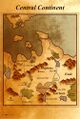 Map
Map -
 Page 29
 -
 Page 72
 -
 Page 117
 -
 Page 153
 -
 Page 171
 -
 Page 207
 -
 Page 235
 -
 Page 255
 -
 Page 277


Map
For anybody wanting to read the map (or edit it), its names are as follows (from top left to bottom right). Those Marked with a * have comments in the discussion page.
大陸中央部 - Centre Continent*
ゾンガー: Zongha* ホーリン地溝: Houlin Rifts ズィム川: Zwimm River メフィウス: Mephius ソロン: Solon イドロ: Idoro エンデ: Ende ドゥーミック平: Domick Flats 聖臨の谷: Seirin Valley ビラク: Birac ノーゼン山地: Nohzen Mountains ヴラド高地: Vlad Plateau ブルーノ丘陵: Bruno Hills* ガーベラ: Garbera 大森林: Great Woods タウーリア: Taúlia* アプター: Apta ユノス川: Yunos River マヴァント湖: Mavant Lake
| Return to Main Page | Forward to Prologue |